Haryana is a state in northern India. As of 2021, there are a total of 22 districts in Haryana.
Sirsa district is the largest district by area and Faridabad District is the smallest district in Haryana. Faridabad District is the most populated and Charkhi Dadri District is the least populated district in Haryana.
District of East Haryana is one of the most flourished areas in this state. The districts are located very near to Delhi, the National Capital of India.Districts of East Haryana are dotted with the history of Mahabharata Era and the later history of India. These districts are Sonipat district, Panipat district, Kurukshetra district, Karnal District and Jhajjar District.Haryana is a state in Northern India. It is bounded by Punjab on the northwest, on the north and northeast by Himachal Pradesh and Uttarakhand, on the east by Uttar Pradesh and the union territory of Delhi, and on the south and southwest by the state of Rajasthan. The capital of Haryana is Chandigarh and it is also the capital of the neighbouring state of Punjab. However, the biggest city in the state is Faridabad. The state was formed on November 1, 1966.
The total area of the state is 44,212 km2 (17,070 sq mi), which makes it the 21st biggest state in India by area. As laid down by the census performed in 2011, the population of the state is 25,353,081, making it the 18th most populated state in India. The density of the population in Haryana is 573/km2 (1,480/sq mi).Sonipat District
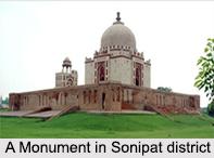
Sonipat district is one of the 21 districts of Haryana. Sonipat town is the district headquarters. It is a part of National Capital Region along with Delhi, Gurgaon, Faridabad, Noida, Ghaziabad. Sonipat district borders Delhi in south, Panipat Dist
Sonipat District- Sonipat district is one of the 21 districts of Haryana. Sonipat town is the district headquarters. It is a part of National Capital Region along with Delhi, Gurgaon, Faridabad, Noida, Ghaziabad. Sonipat district borders Delhi in south, Panipat District in the north, Jind District in the north-west, Uttar Pradesh state in the east with the Yamuna River acting as a border and Rohtak District in the west.
Panipat District- Panipat district is blessed with the historical town of Panipat, which is the administrative headquarters of the district. The district occupies an area of 1268 square km, making it the 19th largest in the state with Gurgaon and Panchkula following it. This area is known in Indian history for the battles during Delhi Sultanate era and the Mughal Era.
Kurukshetra District- Kurukshetra district is headed by the town of Kurukshetra. It is a sacred place for the Hindus. It is the administrative headquarters of this district. The district occupies an area of 1682.53 km ². The district has a population of 825,454. This district is part of Ambala division.rict in the north, Jind District in the north-west, Uttar Pradesh state in the east with the Yamuna River acting as a border and Rohtak District in the west.